Search Books
Mid-Atlantic Lighthouses: I… Northwest Lighthouses: Illu…

Mid-Atlantic Lighthouses Illustrated Map & Guide Laminated Poster

Author Bella Stander
Publisher Bella Terra Publishing
Category Map
📄 Viewing lite version Full site ›
🌎 Shop on Amazon — choose country
12.95 USD
🛒 Buy New on Amazon 🇺🇸 🏷 Buy Used — $36.92

✓ Usually ships in 24 hours

Share:
Book Details
Author(s)Bella Stander
ISBN / ASIN1888216352
ISBN-139781888216356
AvailabilityUsually ships in 24 hours
Sales Rank4,498,211
CategoryMap
MarketplaceUnited States 🇺🇸

Description

The illustrated map and guide to all the lighthouses of New Jersey, Southeast Pennsylvania, Delaware, Maryland & Virginia.

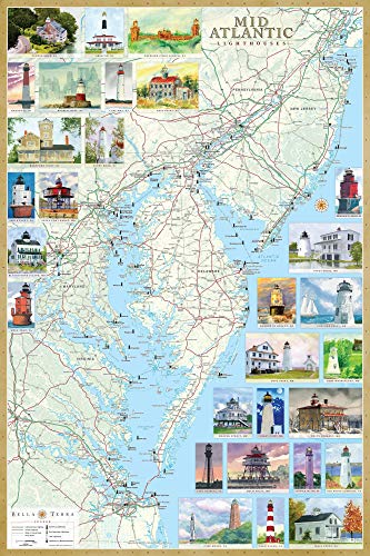
Completely revised and updated, with new cartography, authoritative text and many new illustrations. 71 standing and 103 "lost" lighthouses, plus lighthouse/maritime museums located on a detailed coastal map.
29 original watercolor illustrations--21 newly commissioned.
Reverse has history, description & directions to each lighthouse; directories of lighthouse museums & cruises; intriguing true tales.
Laminated paper with edge seal, 24x36 in, rolled.


For the folded paper edition, type 1888216344 in amazon search box.

Dublin Streetfinder Colour Map
View
Collins Discovering Glasgow: The Illustrated Map (Coll…
View
Planisphere
View
2016 Collins Map of France
View
Collins Pocket Map London
View
MIchelin Local Road Map 562 : Trentino - Alto Adige (I…
View
San Francisco, northern peninsula cities street map, C…
View
Rand McNally Folded Map: Salt Lake City
View
Rand McNally Baltimore, Maryland Street Map
View