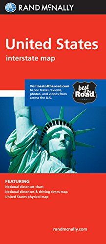
Rand Mcnally United States
Book Details
Author(s)
Rand McNally
Publisher
Rand McNally
ISBN / ASIN
0528881280
ISBN-13
9780528881282
Availability
Only 1 left in stock - order soon.
Sales Rank
#105,065
Category
Map
Marketplace
United States 🇺🇸
Ratings & Reviews
No reviews yet — be the first!
No reviews yet.
Description
Rand McNally's United States folded map features clear, easy-to-read cartography showing all Interstate and U.S. highways, along with clearly indicated cities, points of interest, airports, boundaries, and more.
Rand McNally folded maps have been the trusted standard for years, offering unbeatable accuracy and reliability at a great price.
Interstate and U.S. highways
Indications of cities, points of interest, airports, boundaries, and more
Mileage chart
Mileage & driving times map
National facts and symbols
Toll roads chart
United States physical map
Visitor information
Product Details
Measures 4.125" x 9" and folds out to 25.5" x 36.75".
Similar Products


![South America Classic [Enlarged and Laminated] (National Geographic: Reference Map) (Reference - Continents)](https://www.ebooknetworking.net/books/079/225/med0792250206.jpg)


