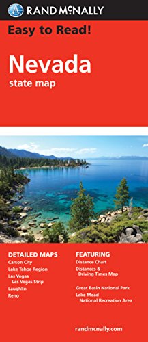
Easy To Read: Nevada State Map (STATE HIGHWAYS)
Book Details
Author(s)
Rand McNally
Publisher
Rand McNally
ISBN / ASIN
0528881892
ISBN-13
9780528881893
Availability
In stock. Usually ships within 2 to 3 days.
Sales Rank
#63,908
Marketplace
United States 🇺🇸
Description
Rand McNally's folded map for Nevada is a must-have for anyone traveling in or through the state, offering unbeatable accuracy and reliability at a great price. Our trusted cartography shows all Interstate, U.S., state, and county highways and much more.
Regularly updated, full-color maps
Clearly labeled Interstate, U.S., state, and county highways
Detail maps of major cities, a mileage chart, and a Mileages & Driving Times Map
Indications of parks, points of interest, airports, county boundaries, and more
Easy-to-use legend
Detailed index
Convenient folded size
Detailed maps include: Carson City, Lake Mead National Recreation Area, Lake Tahoe Region, Las Vegas, Las Vegas Strip, Laughlin, Reno
Similar Products