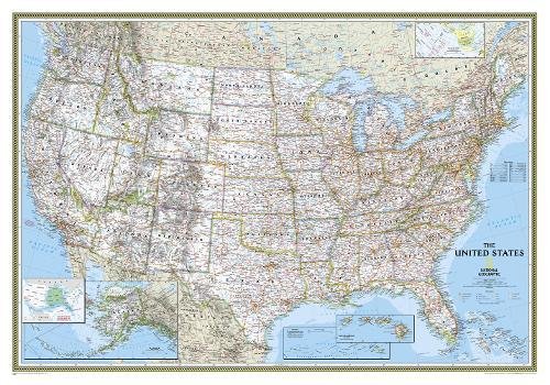
USA Classic Political Map Laminated
The signature Classic style United States map uses a bright, easy to read color palette featuring blue oceans and stunning shaded relief that has been featured on National Geographic wall maps for over 75 years. All 50 States are featured including insets for Alaska and the Hawaiian Islands. An inset demonstrating the relative size of Alaska is shown as well. All major cities, transportation routes, State boundaries, National Parks, inland waterways, and mountain ranges are clearly displayed and labeled. It is truly an iconic map that never goes out of style.
The map is encapsulated in heavy-duty 1.6 mil laminate which makes the paper much more durable and resistant to the swelling and shrinking caused by changes in humidity. Laminated maps can be framed without the need for glass, so the fames can be much lighter and less expensive.
- Map Scale = 1:4,561,000
- Sheet Size = 43.5" x 30.5"
![World Executive [Mural] (National Geographic Reference Map)](https://www.ebooknetworking.net/books/079/223/med0792230345.jpg)
![United States Executive [Laminated] (National Geographic: Reference Map) (Reference - U.S.)](https://www.ebooknetworking.net/books/079/223/med0792233786.jpg)


![China Classic [Tubed] (National Geographic: Reference Map) (Reference - Countries & Regions)](https://www.ebooknetworking.net/books/079/224/med0792249615.jpg)
![France, Belgium, and The Netherlands Classic [Tubed] (National Geographic Reference Map)](https://www.ebooknetworking.net/books/079/224/med0792249658.jpg)
![Germany Classic [Tubed] (National Geographic Reference Map)](https://www.ebooknetworking.net/books/079/224/med0792249674.jpg)
![Greece Classic [Tubed] (National Geographic: Reference Map) (Reference - Countries & Regions)](https://www.ebooknetworking.net/books/079/224/med0792249690.jpg)
![Holy Land [Tubed] (National Geographic: Reference Map)](https://www.ebooknetworking.net/books/079/224/med0792249712.jpg)
![Italy Classic [Tubed] (National Geographic Reference Map)](https://www.ebooknetworking.net/books/079/224/med0792249755.jpg)
