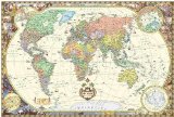
Children's World Map (Wall Map) (Illustrated World Map) (Map)
You can still browse on Amazon. Try another country above.
No reviews yet.
A colorful, educational world map which will keep your kids entertained for hours. The children's world map was specially produced for kids, and provides a great way for you to spend time with your kids and educate them, while all the time having fun! In this increasingly connected world, it's important to give your kids an understanding of different countries and cultures.
The map offers a wealth of information. It shows more geographical features including: international borders, flags, countries, major cities, seas and oceans, mountain ranges, major rivers. More than 300 of illustrations and descriptions on the world map show: animals throughout the world and indicates the areas where they live, explorers, historical items, cultural items, ships and sailboats, legend of icons.
Size: 27.5x39 inches, Rolled
Laminated with Polypropylene film (Standard thermal laminating film). You can write with dry erase marker or water-based pen above it and wash it easy.


![Illustrated map of the US for kids (Laminated Children's Wall Map of the US for Kids) [Map])](https://www.ebooknetworking.net/books/987/166/med987166303X.jpg)