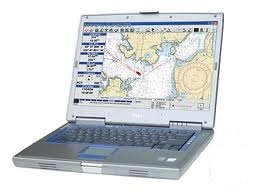
NOAA Charts & SeaClear II (PC GPS Chart Plotter)
Price not available for United Kingdom
You can still browse on Amazon. Try another country above.
Book Details
Ratings & Reviews
No reviews yet — be the first!
No reviews yet.
Description
Why look at a 4 inch screen on a chartplotter when you can use the larger screen on your laptop. This DVD comes with all the software and charts to turn your laptop in to a marine chartplotter. There are more than 2200 charts on the DVD. NOAA Raster Navigational Charts® are full-color, geo-calibrated, high detail, digital images of NOAA's entire suite of paper charts.
Why spend $400.00 to $2000.00 for a chartplotter when you can purchase my software and chart package for a lot Less.
Features and Requirements:
Works on most PC's running Windows 95 and up, but as Windows 95/98/ME has many limitations, Windows 2000/XP/Vista is recommended.
The GPS must be capable of transmitting NMEA 0183 1.5 or higher messages. Most modern GPS units with PC communication will work. On units capable of receiving NMEA waypoint and route data, uploading from the PC is supported.
Unlimited number of routes is easily created. Maximum number of route points limited by memory only. Several routes may be joined. Tracks can be imported. Cross track error alarm. Calculation of time to go, total time to go, bearings, steering indicator and output to NMEA.
Unlimited number of waypoint files can be created. Maximum number of waypoints limited by memory only. Multiple files can be merged. Quick locate of waypoint loads map and centers waypoint on screen.
Tracks: Tracks are saved to file and plotted. Saved tracks can later be plotted and used to create routes.
Logbook: Automatic and manual log book entries into a text file.
Import / Export: Import and export of routes, waypoints and tracks using G7ToWin and to G7T and Waypoint+ text file format. Export of waypoints and routes to supporting NMEA devices.
Language independent: Most text and menus can be user translated to any language without any special tools. Several languages are included.
NMEA Depth, Wind, Compass and AIS. GPS based Log, Hours and estimated fuel consumption. Night modes with shaded charts.


